Local Government
Greater Geraldton
Region
Midwest
Through Woodenooka & Tallering Peak N from Mullewa
Bicentennial Heritage Trail
De Gray Mullewa Stock Route
Greater Geraldton
Midwest
Constructed from 1870
| Type | Status | Date | Documents |
|---|---|---|---|
| Heritage List | Adopted | 15 Dec 2015 | |
| State Register | Registered | 07 Dec 2022 | HCWebsite.Listing+ListingDocument, HCWebsite.Listing+ListingDocument |
| Type | Status | Date | Documents |
|---|---|---|---|
| (no listings) |
| Type | Status | Date | Grading/Management | |
|---|---|---|---|---|
| Category | ||||
| Municipal Inventory | Adopted | 24 Jun 2014 | Category 3 | |
| Library Id | Title | Medium | Year Of Publication |
|---|---|---|---|
| 7138 | The pathways of the drover. | Journal article | 1994 |
| 1047 | A time to keep: preserving the past for the present. | Book | 1994 |
Other Built Type
| Epoch | General | Specific |
|---|---|---|
| Present Use | Transport\Communications | Road: Other |
| Original Use | Transport\Communications | Road: Other |
| General | Specific |
|---|---|
| TRANSPORT & COMMUNICATIONS | Droving |
This information is provided voluntarily as a public service. The information provided is made available in good faith and is derived from sources believed to be reliable and accurate. However, the information is provided solely on the basis that readers will be responsible for making their own assessment of the matters discussed herein and are advised to verify all relevant representations, statements and information.
Constructed from 1890
Wells and other water sources were critical in the opening up and development of the district and were crucial in the droving of stock. Each individual watering point has its own value, however as a whole they indicate the historic routes taken by drovers and travellers.
The closest well to Mullewa that remains is 4.9km north, on the west side of the Camarvon Rd and north of Sutherland Road, along a dirt track. This is the Perkins No.2 Government Well, which was sunk in January 1934 by Frank Field. 34 feet deep, the stone lined well has a timber lining to the top 1 metre and a metal grille cover. The well, which supplied an average of 16 gallons per hour of fresh water, is surrounded by a partly collapsed timber pole fence. Nearby is a Bicentennial plaque mounted on a large rock. The first Perkins Well was sunk and equipped by a Government well-sinker in 1897where the main road crosses the Wooderarrung River, but this went salty. There are further water sources at Woodenooka, 14.9km from Mullewa, west of the Carnarvon Road (built 1895), at Waterfall, 6.5km from Mullewa, east of the Camarvon Road (natural pool), at White Government Well, 10kmfrom Mullewa, west of the Camarvon Road (sunk 1920), at Woodenooka, 14.9kmfrom Mullewa, west of Carnarvon Road (built 1895) and at Hughies Rocks, 32.6km from Mullewa, east of Carnarvon Road (natural pool, reserved 1880).
In the 1860s and 1870s the demand for grazing land increased, as did the need to find permanent water supplies for stock and droving purposes. This expansion caused resentment among the local Aboriginal tribes as water and food supplies were depleted by stock, occasionally leading to violent altercations with settlers and shepherds. By the 1870s 'runs' or pastoral stations had been taken up in the Mullewa and Murchison area and a main route became established to provide access for travellers on foot, cart or horseback. Sheep and cattle were walked out from established runs around Geraldton and the Irwin River by shepherds. The sheep were taken back to their parent runs for shearing, and the pathways used became recognised stock routes with stopping and resting places 10 to 15 miles apart at watering points. Some of these were springs or rockholes, and others were wells dug for shepherds. In the 1890s Government well-sinkers established further wells and equipped them with block and tackle pulleys for whipping (drawing) water and a Government issue canvas bucket which held 44 gallons. In 1905 the entire network of northern and eastern stock routes were gazetted as A Class Reserves, 80 chains wide, from the Kimberley in the far north to Perth. The stock route between the De Grey River and Mullewa was number 9701. In the 1950s the transportation of stock in motor trucks on prepared road systems became common place. Many of the roads were developed along the old stock routes, following the most suitable terrain. Since then some of the wells have deteriorated, others have been restored and are included in heritage trails.
This information is provided voluntarily as a public service. The information provided is made available in good faith and is derived from sources believed to be reliable and accurate. However, the information is provided solely on the basis that readers will be responsible for making their own assessment of the matters discussed herein and are advised to verify all relevant representations, statements and information.
Port Hedland
Port Hedland
Pilbara
| Type | Status | Date | Documents |
|---|---|---|---|
| (no listings) |
| Type | Status | Date | Documents |
|---|---|---|---|
| (no listings) |
| Type | Status | Date | Grading/Management | |
|---|---|---|---|---|
| Category | ||||
| Register of the National Estate | Indicative Place | |||
04004 Mundabullangana Station
Individual Building or Group
| Epoch | General | Specific |
|---|---|---|
| Original Use | FARMING\PASTORAL | Shed or Barn |
| Type | General | Specific |
|---|---|---|
| Wall | METAL | Corrugated Iron |
| Wall | TIMBER | Log |
This information is provided voluntarily as a public service. The information provided is made available in good faith and is derived from sources believed to be reliable and accurate. However, the information is provided solely on the basis that readers will be responsible for making their own assessment of the matters discussed herein and are advised to verify all relevant representations, statements and information.
This information is provided voluntarily as a public service. The information provided is made available in good faith and is derived from sources believed to be reliable and accurate. However, the information is provided solely on the basis that readers will be responsible for making their own assessment of the matters discussed herein and are advised to verify all relevant representations, statements and information.
6 Anderson St Port Hedland
Cnr Anderson & Wedge Sts
Port Hedland
Pilbara
Constructed from 1901 to 1970
| Type | Status | Date | Documents |
|---|---|---|---|
| Heritage List | Adopted | 23 Aug 2017 | |
| State Register | Registered | 14 May 1999 | HCWebsite.Listing+ListingDocument, HCWebsite.Listing+ListingDocument |
| Type | Status | Date | Documents |
|---|---|---|---|
| (no listings) |
| Type | Status | Date | Grading/Management | |
|---|---|---|---|---|
| Category | ||||
| Municipal Inventory | Adopted | 31 Dec 1996 | Category 1 | |
| Library Id | Title | Medium | Year Of Publication |
|---|---|---|---|
| 4435 | Dalgety House restoration: final report | Report | 2000 |
| 3615 | Dalgety House Conservation Plan | Heritage Study {Cons'n Plan} | 1998 |
Individual Building or Group
| Epoch | General | Specific |
|---|---|---|
| Present Use | EDUCATIONAL | Museum |
| Original Use | RESIDENTIAL | Single storey residence |
| Style |
|---|
| North-West Vernacular |
| Type | General | Specific |
|---|---|---|
| Roof | METAL | Corrugated Iron |
| Wall | TIMBER | Other Timber |
| General | Specific |
|---|---|
| OCCUPATIONS | Commercial & service industries |
This information is provided voluntarily as a public service. The information provided is made available in good faith and is derived from sources believed to be reliable and accurate. However, the information is provided solely on the basis that readers will be responsible for making their own assessment of the matters discussed herein and are advised to verify all relevant representations, statements and information.
Dalgety House is of exceptional significance as a rare extant example of early twentieth century north west housing designed to respond to the climate. It has significant associations with Dalgety Company and their role in the pastoral and other north west industries, and represents the north west lifestyle in provision of employee housing. Dalgety House one of the few original residences of the period in the town or the commercial district, and presents a modest landmark that contributes to the character and streetscape of the town.
Single storey timber framed corrugated iron clad bungalow raised on stumps with verandahs enclosed by dado walls and shutters. Hipped roof clad with corrugated iron. Minimal setbacks to both street fronts, with some plantings.
Dalgety’s established an agency in Port Hedland in 1899, to service the pearling and shipping industries. Dalgety House was constructed in c.1901 for the Dalgety Company, to provide housing for the Manager stationed in Port Hedland. By the 1930’s and 1940s Dalgety’s business was predominantly associated with the pastoral industry. In c.2000 with the assistance from Heritage Council funding, the place was extensively restored and re-opened as the Museum, facilitating public access and appreciation of the museum collection and the house.
Integrity Moderate: change from residential to museum Authenticity: Moderate Changes to place Extensively restored in c.2000. No additions to original structure and form.
| Ref ID No | Ref Name | Ref Source | Ref Date |
|---|---|---|---|
| Town of Port Hedland MI | 1996 | ||
| B Callow & Associates; "Conservation Plan". | Town of Port Hedland | 1998 |
This information is provided voluntarily as a public service. The information provided is made available in good faith and is derived from sources believed to be reliable and accurate. However, the information is provided solely on the basis that readers will be responsible for making their own assessment of the matters discussed herein and are advised to verify all relevant representations, statements and information.
Lot 37 Edgar St Port Hedland
Art Gallery and Exhibition Centre
Olde St Matthew's Church
Port Hedland
Pilbara
Constructed from 1917 to 1918
| Type | Status | Date | Documents |
|---|---|---|---|
| Heritage List | Adopted | 23 Aug 2017 | |
| State Register | Registered | 01 Mar 1994 | HCWebsite.Listing+ListingDocument |
| Type | Status | Date | Documents |
|---|---|---|---|
| (no listings) |
| Type | Status | Date | Grading/Management | |
|---|---|---|---|---|
| Category | ||||
| Register of the National Estate | Indicative Place | |||
| Classified by the National Trust | Classified | 02 Nov 1983 | ||
| Municipal Inventory | Adopted | 31 Dec 1996 | Category 1 | |
Demolished. HCWA Development Committee approved the dismantling due to extensive termite damage. Interpretation required, no reconstruction required.
| Library Id | Title | Medium | Year Of Publication |
|---|---|---|---|
| 5023 | St Matthew's Anglican Church (fmr), Port Hedland, Western Australia : conservation plan. May 2001 | Heritage Study {Cons'n Plan} | 2001 |
Individual Building or Group
| Epoch | General | Specific |
|---|---|---|
| Original Use | RELIGIOUS | Church, Cathedral or Chapel |
| Present Use | COMMERCIAL | Market Building |
| Style |
|---|
| Vernacular |
| Type | General | Specific |
|---|---|---|
| Wall | TIMBER | Weatherboard |
| Roof | METAL | Corrugated Iron |
| General | Specific |
|---|---|
| SOCIAL & CIVIC ACTIVITIES | Religion |
This information is provided voluntarily as a public service. The information provided is made available in good faith and is derived from sources believed to be reliable and accurate. However, the information is provided solely on the basis that readers will be responsible for making their own assessment of the matters discussed herein and are advised to verify all relevant representations, statements and information.
Constructed from 1908, Constructed from 1989
The site and rectory are significant for the associations with the Anglican Church in Port Hedland between 1908 and 1989, and for the sense of place.
The church was a single storey timber framed and weatherboard clad structure with a gable corrugated iron roof. The rectory is a single storey timber framed and fibro cement clad cottage. The church was set back from the road, central on the site, with the rectory at the rear, with ROW access.
Originally built in 1908, by 1916 a rectory was constructed at the rear of the church. In 1917, fire destroyed the church and it was rebuilt in 1918. The roof was replaced in 1977 after a cyclone. The place continued to be a place of worship for the Anglican congregation until 1989 when the property was sold to the Port Hedland Tourist Bureau. It was extensively restored in 1993 and opened as ’The Olde St Matthew’s Art Gallery’ and exhibition centre. The church building subsequently fell into disrepair and in 2002, extensive termite damage was evident. Despite Lotterywest funding for restoration, the termite damage was extensive and the church was demolished in late 2003.
Integrity Rectory: moderate Authenticity: Rectory: moderate degree Changes to place Church: demolished in 2003. Rectory- refurbished in 1993. 1908- destroyed by fire 1917, rebuilt 1918, restored 1989, demolished 2003 Rectory: 1916-destoryed by cyclone 1939. Existing constructed c.1940.
Fair
| Ref ID No | Ref Name | Ref Source | Ref Date |
|---|---|---|---|
| State Heritage Office; "Register Documnetation Place no. 2285". | |||
| Town of Port Hedland MI | 1996 |
This information is provided voluntarily as a public service. The information provided is made available in good faith and is derived from sources believed to be reliable and accurate. However, the information is provided solely on the basis that readers will be responsible for making their own assessment of the matters discussed herein and are advised to verify all relevant representations, statements and information.
North West Coastal Hwy Port Hedland
NW Coastal Hwy-Wedgefield Coast Road comprises: Shearing Shed, Woolshed, quarters & homestead group Survey sketch 4004A & 4004B has been prepared by SE&C Also Shire of Roebourne
Mundabullanga
Port Hedland
Pilbara
Constructed from 1927
| Type | Status | Date | Documents |
|---|---|---|---|
| Heritage List | Adopted | 23 Aug 2017 | |
| State Register | Registered | 16 May 2008 | HCWebsite.Listing+ListingDocument, HCWebsite.Listing+ListingDocument |
| Type | Status | Date | Documents |
|---|---|---|---|
| (no listings) |
| Type | Status | Date | Grading/Management | |
|---|---|---|---|---|
| Category | ||||
| Municipal Inventory | Adopted | 31 Dec 1996 | Category 1 | |
| Register of the National Estate | Removed from RNE | |||
| Classified by the National Trust | Classified | 05 Dec 1983 | ||
| Register of the National Estate | Nominated | 02 Mar 1984 | ||
Mundabullangana Station homestead group is well maintained. The homestead and other stone structures are in fair to good condition, while the older iron framed structures are in fair condition. The shearing shed group has not been in use since 1985, and has not been maintained. The shearing shed is in fair to poor condition. The quarters, cookhouse and ablutions have sustained considerable cyclone damage and are in poor to very poor condition, with most of the damaged buildings beyond repair.
| Library Id | Title | Medium | Year Of Publication |
|---|---|---|---|
| 5921 | Off-shears : the story of shearing sheds in Western Australia. | Book | 2002 |
Individual Building or Group
| Epoch | General | Specific |
|---|---|---|
| Original Use | MONUMENT\CEMETERY | Cemetery |
| Present Use | FARMING\PASTORAL | Shed or Barn |
| Original Use | FARMING\PASTORAL | Other |
| Original Use | FARMING\PASTORAL | Shed or Barn |
| Original Use | FARMING\PASTORAL | Kitchen |
| Original Use | FARMING\PASTORAL | Servants or Shearers Quarters |
| Present Use | FARMING\PASTORAL | Homestead |
| Original Use | FARMING\PASTORAL | Stockyard |
| Original Use | FARMING\PASTORAL | Homestead |
| Style |
|---|
| Vernacular |
| Victorian Georgian |
| Type | General | Specific |
|---|---|---|
| Roof | METAL | Zincalume |
| Wall | STONE | Other Stone |
| Wall | METAL | Corrugated Iron |
| Roof | METAL | Corrugated Iron |
| General | Specific |
|---|---|
| PEOPLE | Aboriginal people |
| PEOPLE | Early settlers |
| DEMOGRAPHIC SETTLEMENT & MOBILITY | Immigration, emigration & refugees |
| OCCUPATIONS | Commercial & service industries |
This information is provided voluntarily as a public service. The information provided is made available in good faith and is derived from sources believed to be reliable and accurate. However, the information is provided solely on the basis that readers will be responsible for making their own assessment of the matters discussed herein and are advised to verify all relevant representations, statements and information.
Constructed from 1878, Constructed from 1879
Mundabullangara Homestead is significant as a fine representative example of a pastoral homestead. It has significant associations with pioneering pastoralists MacKays, in the 1870s and their organised labour, with the use of Asian indentured labourers, mainly Malays and Cantonese Chinese, and was the first station in the Pilbara to introduce the payment of award wages for Aboriginal workers.
Single storey bluestone and concrete homestead has an expansive single pitched roof and a surrounding verandah supported by cast iron posts. Features include a large concrete arch entrance and full-length shuttered doors open onto the verandahs. Oasis. The homestead group comprising: the homestead, the windmill room, store, old kitchen, grave, and other more utilitarian structures are located around an expansive grassed area.
It is recorded that a sealed history is stored in a bottle built into a corner of the building. Mundabullangara Homestead was the first pastoral lease taken up in the region south west of Port Hedland by European settlers, the MacKays, who between 1872 and 1923 developed it into one of the largest and most successful enterprises of its kind that has continued pastoral use into the twenty-first century. The MacKays organised labour in the latter part of the nineteenth century, with the use of Asian indentured labourers, mainly Malays and Cantonese Chinese, which was not a widespread practice in the pastoral industry, and was the first station in the Pilbara to introduce the payment of award wages for Aboriginal workers, in the mid 1940s, under the management of R. F. Lukis, and maintained a longstanding use of Aboriginal labour, from the 1880s to the 1960s. It was the first pastoral station in the North-West of Western Australia at which Birdwood Grass was sown and, following success it became widely used in the region. The significant shearing shed and woolstore were demolished in cyclone in recent decades.
Integrity: High degree Authenticity: High degree Changes to place: Minimal evident
Good
| Ref ID No | Ref Name | Ref Source | Ref Date |
|---|---|---|---|
| J Hardie; "Nor’ Westers of the Pilbara breed: The story of brave ancestors who pioneered the outback Pilbara of Western Australia". | The Shire of Port Hedland, | 1981 |
This information is provided voluntarily as a public service. The information provided is made available in good faith and is derived from sources believed to be reliable and accurate. However, the information is provided solely on the basis that readers will be responsible for making their own assessment of the matters discussed herein and are advised to verify all relevant representations, statements and information.
34 Sutherland St Port Hedland
Taplin St bounded by Anderson & Meiklejohn St
Port Hedland
Pilbara
Constructed from 1919
| Type | Status | Date | Documents |
|---|---|---|---|
| Heritage List | Adopted | 23 Aug 2017 | |
| State Register | Registered | 04 Sep 2019 | HCWebsite.Listing+ListingDocument, HCWebsite.Listing+ListingDocument |
| Type | Status | Date | Documents |
|---|---|---|---|
| (no listings) |
| Type | Status | Date | Grading/Management | |
|---|---|---|---|---|
| Category | ||||
| Municipal Inventory | Adopted | 31 Dec 1996 | Category 1 | |
The place contains the only extant remains of a Lock Hospital in Western Australia and represent the consequences of colonial settlement on the population and health of Aboriginal people in North Western Australia, including the establishment of health care facilities to manage the catastrophic impacts of disease and illness on Aboriginal people; the place is representative of the official government policy of treating Aboriginal and non-Aboriginal patients in separate medical facilities, which remained in place until the 1960s when the Commonwealth policy of assimilation was adopted; Lock Hospital (fmr) represents measures undertaken by the Western Australian government to deal with the spread and treatment of infectious disease, in particular venereal disease, amongst Aboriginal people in the North-West of the state Moorgunya Hostel and Dormitories demonstrate changes in Western Australian government policy in the 1960s and 1970s towards assimilation and the provision of educational services and assistance to Aboriginal families.
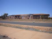
Lock Hospital (fmr) and Burial Ground (1919-1967) is a complex of single storey timber and metal framed buildings clad in metal and compressed fibre comprising elements of the former Lock Hospital Quarters (1919), Matron’s Quarters (1950s), former Isolation Wards (1950s) and former Mortuary (pre-1962) together with archaeological deposits associated with demolished hospital buildings), and later community facilities (former Moorgunya Hostel (1967), and former Dormitories (1967))
Lock Hospital (fmr) and Burial Ground, Port Hedland comprises a complex of single storey timber and metal framed buildings clad in metal and compressed fibre first established in 1919 to provide hospital and isolation nursing for Aboriginal people suspected of having venereal diseases, and later used as a hospital and nursing home. In 1919 Reserve 17014, Lots 211 and 217 were gazetted for the purpose of a Lock Hospital. The site was located on the ‘outskirts’ of the Port Hedland townsite on an area known as Finlay’s Camp. The lock hospital was operating by April 1920. Patients who died were buried in unmarked graves outside the fenced area of the hospital. The graves were reportedly situated to the east of the hospital boundary where Mieklejohn Street now runs adjacent to St Cecilia’s Church and Primary School, and to the north of the boundary in the current location of Moorgunyah Hostel. In 1949, administration of the four Native Hospitals at Port Hedland, Broome, Derby and Wyndham were handed over to the control of Department of Public Health. In the 1950s the Matron’s Quarters (now Community Radio Station) and a new ward, resembling a Nissen hut, (Former Isolation Ward/Nursing Home) were constructed. In 1967 the function (and boundary) of Reserve 17014 was amended to include Lot 841 and reflect the construction of the single storey Moorgunya Hostel facing Sutherland Street. The government-run hostel for Aboriginal children was one of several established in the North West region, which aimed to provide accommodation for children of Aboriginal station workers in order that they could attend high school in town. In 1975 the facility was upgraded with some structures demolished, so by 1977, only three buildings remained from the Lock Hospital phase of the site’s history. The former Matron’s Quarters building (now Community Radio Station) was known as Boab House and was used as emergency accommodation for Aboriginal families. The former Isolation Ward, later Nursing Home building, was in use as a drop in nursing home (now China’s Gym). The former Mortuary building was in use as a store-room. A transportable unit was also present in the southern portion of the site, and in use as a Kindergarten building.
The archaeology of the place has considerable potential to yield information contributing to a wider understanding of the management of venereal and other diseases in the early to mid-twentieth century in the North West of Western Australia. The archaeology of the place has the potential to comprise archaeological artefacts or deposits that may provide further information regarding segregation of males and females in a medical context in Western Australia.
Fair.
| Library Id | Title | Medium | Year Of Publication |
|---|---|---|---|
| 11455 | Regional institutions attended by Aboriginal people in Western Australia | Heritage Study {Other} | 2014 |
| 11429 | Prostitution, Race & Politics: Policing venereal disease in the British Empire | Book | 2003 |
| 11456 | Thematic review of institutions attended by Aboriginal people in Western Australia represented on the Register of Heritage Places and the assessment program. | Heritage Study {Other} | 2016 |
| 8820 | Counting, health and identity ; a history of Aboriginal health and demograpy in Western Australia and Queensland, 1900 - 1940. | Book | 2003 |
| 7599 | Havens of refuge : a history of leprosy in Western Australia. | Book | 1978 |
Individual Building or Group
| Epoch | General | Specific |
|---|---|---|
| Original Use | HEALTH | Hospital |
| Present Use | VACANT\UNUSED | Vacant\Unused |
| Type | General | Specific |
|---|---|---|
| Roof | METAL | Corrugated Iron |
| Wall | METAL | Corrugated Iron |
| General | Specific |
|---|---|
| SOCIAL & CIVIC ACTIVITIES | Community services & utilities |
This information is provided voluntarily as a public service. The information provided is made available in good faith and is derived from sources believed to be reliable and accurate. However, the information is provided solely on the basis that readers will be responsible for making their own assessment of the matters discussed herein and are advised to verify all relevant representations, statements and information.
Constructed from 1918, Constructed from 1919
The remains of Lock Hospital and Aboriginal burial ground are of considerable significance in representing issues associated with Aboriginal health and social conditions in the Pilbara, up to the 1960s when the hospital was closed. The site also represents associations with the Missionary Annie Lock.
The three buildings are single storey timber framed structures. The nursing home building is a ground level pavilion clad with corrugated iron. It is located adjacent to Meikeljon Street midway along the site. The other two buildings are dwellings c.1950s, raised on stumps, clad with Asbestos, with hipped roofs clad with corrugated iron. The extensive site comprises three buildings, and many concrete slab remains of buildings. The site is flat, although there is a steep rise at the north end of the site where other hospital development has taken place in recent decades, fronting Sutherland Street. Those buildings are not part of this ‘place’. There is no indication of where any of the graves are located.
Established in 1919, the Lock Hospital took over after the closure of Dorre and Bernier Islands hospitals in providing hospital and isolation nursing for Aboriginal people. The island hospitals, off the coast of Carnarvon, had provided isolation for aboriginal people suspected of having venereal disease between 1908 and 1918. Lock Hospital was located on the ‘outskirts ‘ of the Port Hedland town, and accepted venereal cases from throughout the Pilbara. It was originally intended to build the hospital on Finucane Island, but there was a lack of water supply. The hospital patients (all Aboriginal men and women) were locked and segregated in barbwire compounds at Lock Hospital. The name ‘Lock’ alludes to the compound conditions of the hospital. Many Aboriginal people died and were buried on the site in unmarked graves. The Lock Hospital operated through until the early 1960s, although venereal disease decreased as a problem in the 1930s. The Lock Hospital became a general hospital. The only remaining original building is currently a community facility. Additional information: The many local Aboriginals who had survived the introduced measles and smallpox epidemics were then confronted with other introduced diseases including STDs. These victims were isolated from the rest of the people, and those who died were buried outside of the fenced area of the Lock Hospital in the sand hill in unmarked graves on the north side where Moorgunyah Hostel now stands and the east side street near the Catholic Church. (Ref: Vincent Lockyer) The name Lock could be derived from a missionary named Annie Lock who was associated with the funding of these hospitals. Lock went to central Australia to do missionary work. Because Lock was a middle-aged single white woman who mingles freely with naked Aborigines, she was ridiculed when she gave evidence into the Coniston massacre. (Ref: Aboriginal History Reader Volume 2)
Integrity: Moderate Degree Authenticity: Moderate Degree Changes to place: Some changes to nursing home building to facilitate changes in use. Current use as a boxing gym has required some modification.
Fair
| Ref ID No | Ref Name | Ref Source | Ref Date |
|---|---|---|---|
| J Hardie; "Nor’ Westers of the Pilbara breed: The story of brave ancestors who pioneered the outback Pilbara of Western Australia". | The Shire of Port Hedland, | 1981 | |
| Mr V Lockyer; "Additional Information". | |||
| Town of Port Hedland MI | 1996 | ||
| S238 "Aboriginal History Reader Volume 2", page 410. |
This information is provided voluntarily as a public service. The information provided is made available in good faith and is derived from sources believed to be reliable and accurate. However, the information is provided solely on the basis that readers will be responsible for making their own assessment of the matters discussed herein and are advised to verify all relevant representations, statements and information.

76 The Esplanade Port Hedland
Medical Staff Quarters
The Green House, cnr McKay & Richardson St
Port Hedland
Pilbara
Constructed from 1907 to 1936
| Type | Status | Date | Documents |
|---|---|---|---|
| Heritage Agreement | YES | 10 Apr 2014 | HCWebsite.Listing+ListingDocument |
| Heritage List | Adopted | 23 Aug 2017 | |
| State Register | Registered | 17 Mar 2006 | HCWebsite.Listing+ListingDocument, HCWebsite.Listing+ListingDocument |
| Type | Status | Date | Documents |
|---|---|---|---|
| (no listings) |
| Type | Status | Date | Grading/Management | |
|---|---|---|---|---|
| Category | ||||
| Register of the National Estate | Indicative Place | |||
| Register of the National Estate | Nominated | 02 Mar 1984 | ||
| Classified by the National Trust | Classified | 05 Dec 1983 | ||
| Municipal Inventory | Adopted | 31 Dec 1996 | Category 1 | |
good
| Name | Type | Year From | Year To |
|---|---|---|---|
| W. B. Hardwick | Architect | - | - |
| Library Id | Title | Medium | Year Of Publication |
|---|---|---|---|
| 9591 | District medical officer's quarters (fmr), 24 Richmond Street, Cnr McKay Street, Port Hedland: conservation plan. | Heritage Study {Cons'n Plan} | 2010 |
Individual Building or Group
| Epoch | General | Specific |
|---|---|---|
| Present Use | HEALTH | Housing or Quarters |
| Original Use | HEALTH | Housing or Quarters |
| Style |
|---|
| Federation Bungalow |
| Type | General | Specific |
|---|---|---|
| Roof | METAL | Zincalume |
| Wall | ASBESTOS | Fibrous Cement, flat |
| Wall | TIMBER | Other Timber |
| General | Specific |
|---|---|
| SOCIAL & CIVIC ACTIVITIES | Law & order |
| SOCIAL & CIVIC ACTIVITIES | Community services & utilities |
This information is provided voluntarily as a public service. The information provided is made available in good faith and is derived from sources believed to be reliable and accurate. However, the information is provided solely on the basis that readers will be responsible for making their own assessment of the matters discussed herein and are advised to verify all relevant representations, statements and information.
Constructed from 1930
The Medical Staff Quarters are significant for the associations with the provision of medical and health services in Port Hedland, including the Resident Doctor, the AIM hospital and Flying Doctor Service, and the continuous use associated with medical staff. The place is an excellent representative example, of an intact and authentic northwest bungalow, and makes a significant contribution to the streetscape and character of Port Hedland town.
Single storey timber framed corrugated iron clad bungalow raised on concrete stumps with perimeter verandahs enclosed by lattice dado walls and shutters. Hipped roof clad with corrugated iron. Lawn and garden Richardson Street setback, overlooking the ocean. Rear yard bounded by McKay and Kingsmill Streets vacant.
The Australian Inland Mission Hospital (AIM) was established in Port Hedland in 1915, and developed in association with the Flying Doctor service. The AIM Hospital was located in Richardson Street, to the east of, and in close proximity to the Medical Staff Quarters and Royal Flying Doctor service radio huts(immediately east of Medical Staff Quarters). The Medical Staff Quarters were constructed in 1930 and housed the town’s first doctor and his surgery. The Australian Inland Mission Hospital was established in 1915, and nursing staff included a matron and two sisters, whose duties rotated between nursing and domestic duties. The government took over the hospital from the Australian Inland Mission during the war. Nursing staff volunteered their services for two years at a time. Until the existing doctors residence was converted into staff quarters, the nurses’ quarters consisted of two small rooms and beds on the verandah. The medical staff quarters were constructed in 1930, originally housing Port Hedland’s first doctor, and his surgery. It remained the doctors residence until 1965, when it was renovated for accommodation for Port Hedland’s nurses and hospital staff. It is also closely associated with the establishment of the Radio Pedal Base and the Flying Doctor Service, in 1953 renamed the Royal Flying Doctor Service.
Integrity: High Degree Authenticity: High Degree Changes to place: 1965 renovation. Rear verandah enclosed and extended.
Good
| Name | Type | Year From | Year To |
|---|---|---|---|
| W. B. Hardwick | Architect | 1930 | - |
| Ref ID No | Ref Name | Ref Source | Ref Date |
|---|---|---|---|
| J Hardie; "Nor’ Westers of the Pilbara breed: The story of brave ancestors who pioneered the outback Pilbara of Western Australia". | The Shire of Port Hedland, | 1981 |
This information is provided voluntarily as a public service. The information provided is made available in good faith and is derived from sources believed to be reliable and accurate. However, the information is provided solely on the basis that readers will be responsible for making their own assessment of the matters discussed herein and are advised to verify all relevant representations, statements and information.